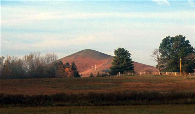
Pic: Trimble Knob, one of the youngest volcanoes on the East Coast. Credit: Virginia DMME
I saw this article today In the UK’s The Daily Mail. Being a Geology buff, I decided to see what it was about. Knowing that some deride the Daily Mail as a not-credible Conservative tabloid, I decided to see for myself whether this story was overblown sensationalist tabloid fluff, or whether it had any merit on its own.
Anyone familiar with the geomorphology of the Southeastern United States, knows that the Appalachian Mountains are old eroded fold created mountains and that the area to the South and East of the Ohio River valley generally slopes towards sea-level with Florida being very flat and mostly only just meters or less above sea level. This is indicative of a general subsidence, or lowering of land mass over millions of years. To be fair to the Mail, they did acknowledge this long time frame in the article. So the ‘big one’ is not going to happen tomorrow, it’s already been happening and for millions of years.
Underside of North American Plate Peeling Off- and sinking into Asthenosphere:
The source of the Daily Mail’s article backtracked to this article by Science Daily, posted May 3rd, 2016. Lending credibility to the Mail’s article with it’s somewhat sensationalist headline “Giant Chunks of Earth’s Mantle Falling Off…”
“According to Biryol, pieces of the mantle have most likely been breaking off from underneath the plate since at least 65 million years ago. Because the researchers found fragments of hard rocks at shallow depths, this process is still ongoing and likely to continue into the future, potentially leading to more earthquakes in the region, he said.” Biryol is the lead researcher of the study:
C. Berk Biryol, Lara S. Wagner, Karen M. Fischer, Robert B. Hawman.Relationship Between Observed Upper Mantle Structures and Recent Tectonic Activity Across the Southeastern United States.Journal of Geophysical Research: Solid Earth, 2016; DOI:10.1002/2015JB012698
Also posted May 3rd at UNC Chapel Hill is this essentially same summation of the immediate above article.
Contemplating future maps of North America would only serve to confuse the issue, not only because of the great time scale involved with this kind of long term change, but because of countless other factors that would affect the design of such a map: Subsidence/Uplift, Ice accumulation/Ice melt, Erosion/Deposition, the dynamics and changeability of tectonic plate motions.
But the idea of sections of the North American plate breaking off from below and thinning the area under the Southeastern states does explain how there came to be a few volcanoes in the vicinity of what is now Virginia:
“Instead, the team proposes that magma reached the surface as pieces of the thick crust beneath Virginia peeled away like sloughing skin — a process called delamination. Afterward, magma seeped through the newly thinned crust, reaching the surface through pre-existing cracks in the overlying rock. In this model, the Virginia lava is the chemical cousin of eastern Atlantic volcanoes, because their sources are both deeply buried leftovers from the breakup of Pangaea, the supercontinent. “– See more at: East Coast Youngest Volcanoes
And from the same live Science link immediately above:
“The shedding crust under Virginia could underlie topographic changes in the Appalachians, such as their recent face-lift. The mountains are more rugged than they should be, given their age and the tectonic quiescence of the East Coast.“
